Open for comments until 25 May 2021 – Extended to 31 May 2021 – Leave your comment(s) below
A Logical Framework methodology was used to design a holistically consistent structure of goals, outcomes that leads to achievement of these goals, outputs that together will materialize into desirable outcomes, and finally activities through which outputs will be delivered.
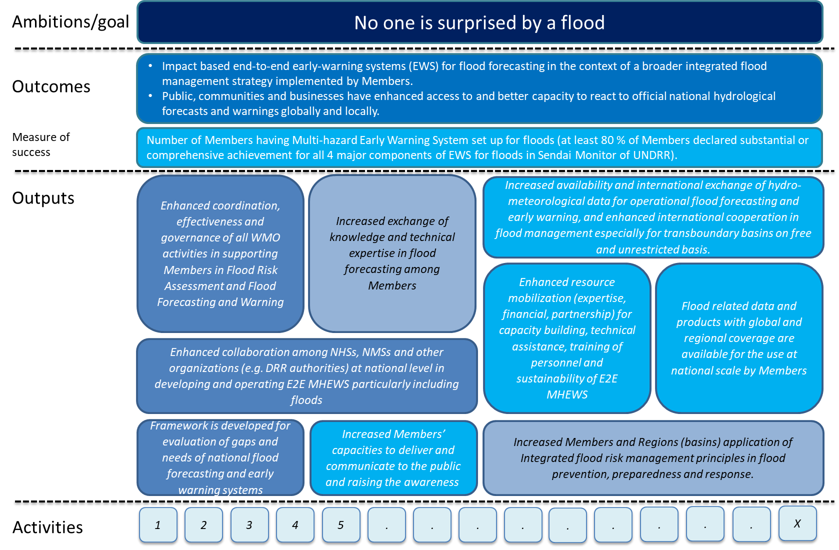
A schematic illustration of the resulting proposal is provided in the following figure.
The Table below provides a list of proposed activities grouped by outputs. More details can be found in the following table/document where for some of the activities additional features are proposed (such as responsibility, time, linkages, etc.). The Table is intended to become an integral part of the Action Plan as its annex.
ID |
Activity |
description |
B.1 |
Enhanced coordination, effectiveness and governance of all WMO activities in supporting Members in Flood Risk Assessment and Flood Forecasting and Warning |
|
B.1.1 |
FFI-AG reinforced coordination mechanisms of activities for Flood Risk Assessment, Forecasting and Warning across WMO, as well as in collaboration with international actors |
to streamline ongoing hydrological programmes and initiative ensuring coherence and consistency, alignment to the plan, effectiveness and efficient use of resources, support to international agenda for DRR, establishing new coordination mechanisms |
B.1.2 |
Establish effective joint planning and implementation mechanisms with major partners and activities (IFI, UNDRR, UNEP….) |
Better coordination of UN flood related activities brings more effective delivery on flood risk assessment and forecasting around the globe. |
B.1.3 |
Establish guiding principles and agreements with private sector to support flood related early warning and risk management |
Private sector could offer technologies like AI or cellphone applications that enable enhancement of services in flood forecasting. Searching opportunities for cooperation via agreements and pilot projects. |
B.2 |
Framework is developed for evaluation of gaps and needs of National flood forecasting and early warning systems |
|
B.2.1 |
Assessment Guidelines web based tool and community |
further development and implementation of the assessment guidelines as a tool for self- assessment (or assessment by expert teams through WMO), to identify capabilities and needs in national capabilities to deliver flood forecasting services and warnings; implementation of a web based tool, based on simplified assessment guidelines, to identify national capabilities and needs |
B.3 |
Increased exchange of knowledge and technical expertise in flood forecasting among Members |
|
B.3.1 |
Community of Practice on End-to-End Early Warning Systems for Flood Forecasting, including guidance on emerging technologies and services for data acquisition and analysis |
developing mechanisms on implementing recommended practices via team of experts to support knowledge exchange. This will be complemented by a repository of capacity building materials (guidance, e-learning); role of the new technologies to address geographical constraints or insufficient local resources |
B.4 |
Enhanced collaboration among NHSs, NMSs and other organizations (e.g. DRR authorities) at national level in developing and operating E2E MHEWS particularly including floods |
|
B.4.1 |
Inclusion of different stakeholders (energy-water-food) needs and requirements, moving towards MHEWS approach (e.g. with the integration of FFGS/CIFI/SWFP) for the possible future integration of hydrology in GMAS (including reflecting hydrological hazards in the catalogue of hazardous events) |
compilation of success stories for collaboration among NMHSs and DRR authorities, create incentives to work together and share data/information and services |
B.4.2 |
support to humanitarian organization for real time risk assessment |
Contribution to GMAS related to flood hazards relevant for humanitarian activities around the World |
B.5 |
Increased availability and international exchange of hydro-meteorological data for operational flood forecasting and early warning, and enhanced international cooperation in flood management especially for transboundary basins on free and unrestricted basis. |
|
B.5.1 |
Basic observation network – hydrology and cryosphere established |
See cross-cutting issues A.10.1 |
8.5.2 |
WHOS – operational data exchange |
See cross-cutting issues A.10.2 |
8.5.3 |
Increased additional / voluntary data sharing including forecast products, Satellite data/products availability for flood forecasting |
See cross-cutting issues A.10.3 |
8.5.4 |
Statement on network design with respect to floods forecasting and management |
See cross-cutting issues A.10.4 |
B.6 |
Enhanced resource mobilization (expertise, financial, partnership) for capacity building, technical assistance, training of personnel and sustainability of E2E MHEWS |
|
B.6.1 |
Project proposals development support |
See cross-cutting issues A.7.1 |
B.7 |
Flood related data and products with global and regional coverage are available for the use at national scale by Members |
|
B.7.1 |
GDPFS – hydrological centers including regional forecasting centers/systems developed |
Establishment of RSMC centers with function in the field of operation flood forecasting to support Members with global and regional product and verification. |
B.7.2 |
inventory of world-wide and regional free and public data and products for Flood forecasting; and inventory of international interoperable models and platforms |
Develop an update the inventory of state of the art tools that are freely available for use in flood forecasting or products that might be used at national and local scale to support flood forecasting activities (such as DEWETRA, Glofas, efas, DHI-UNEP, Sustainable FFGS} as an entry reference page |
B.8 |
Increased Members’ capacities to deliver and communicate to the public and raising the awareness |
|
B.8.1 |
Collection of success stories, challenges and needs |
includes case studies on CAP application to hydrological hazards, communication of uncertainty |
B.8.2 |
Guidelines on Flood Risk assessment/mapping and “Impact Based Forecasting” |
Better understanding of flood hazard and flood risk and their changes within the year, season, day as well as long-term trends based on concepts used e.g. in EU Floods Directive etc. |
B.8.3 |
Enhanced national consultations/communication between forecasters and users |
i) guidelines based on good practices developed and implemented ii) compilation of list of requirements from users and their decisions /expectations and how to research on these (guide) iii) catalog of case studies of product and service development as well as marketing strategies for customers and development of process/check list, methodology to support strategic service planning of NMHSs including catalogue of products and services in response to customer requirements, including: Awareness raising on flood risk management (follow up from previous APFM activities, such as CBFM) |
B.8.4 |
Guidelines for harmonizing information and products that are used to communicate forecasting results and related risks |
|
B.9 |
Increased Members and Regions (basins) application of Integrated flood risk management principles in flood prevention, preparedness and response. |
|
B.9.1 |
APFM capacity building |
activities of capacity building in flood forecasting and integrated flood management |
Please comment on the list of activities by answering to the following questions using the “Leave a reply” form at the bottom of this page:
- Are any substantial activities missing from your point of view (please keep in mind that, given their nature, they may be also listed under cross-cutting issues)?
- Are all listed activities feasible and meaningful?
- Do you want to propose some changes to definition, description or other features of individual activities? Please refer to ID of the activity.
- Any other comments are welcome as well.
In addition please indicate, using the survey form here below, your preferences concerning the priorities by assigning ‘High priority’ to those activities you consider critical for the Action Plan for Hydrology and which you’d like to promote. At the same time, please assign ‘no priority’ to activities that should be downgraded or dropped from the Action Plan:
This post is open for comments until 25 May 2021 – Extended to 31 May 2021.
Thank you for your inputs!
Mohamed HOUSSEINI IBRAHIM30 May 2021 at 0h41
In flood forecasting and management systems, equipment for monitoring, forecasting, mesurement, collecting and analyzing hydrometeorological data has an important role. It is important for WMO to support hydrometeorological services in order to have a reliable and functional system for measuring hydrometeorological and soil characteristics. And also functional and efficient flood forecasting systems and EWS. It is also important to have the mapping of the flood zones so that no one is surprised by a flood. Functional upgrading and significant coverage of hydrometeorological networks would therefore be necessary. There would also be a need for capacity building for better control of hydrometeorological activities. The exchange of data and information between the various actors and institutions can also help reduce the risk of flooding. WMO could also play a role at this level.
Anssi Vähämäki28 May 2021 at 13h16
On behalf of FMI meteorologists and oceanographers:
Good example of a success story which enhances collaboration among NHSs, NMSs and e.g. DRR authorities at national level in floods and increases members capacities to deliver and communicate to the public and raising the awareness is the Finnish virtual Flood Centre. It is virtually co-operated between Finnish Environment Institute and the Finnish Meteorological Institute. Communication includes regular twice a week communication between the operating bodies and enhanced co-operation in actual flood cases. A virtual centre issueing Flood early warnings covering pluvial, fluvial and coastal floods. In actual flood cases the seamless virtual co-operation is the key to provide best possible information to DRR and other authorities.
Yashar Falamarzi26 May 2021 at 6h48
The view of WMO in supporting national and regional hydrological activities is highly appreciated. In my point of view, establishment of effective joint planning and implementation mechanisms with major partners and activities should not be limited to UN bodies. There are lots of local bodies that have good experiences in the related fields. They must be identified and considered.
Mariano Re25 May 2021 at 21h43
Mariano Re (INA, Argentina)
B.8 – Increased Members’ capacities to deliver and communicate to the public and raising the awareness
This item is extremely important. The institutions that offer hydrological services have historically been built from that knowledge. Therefore, they have good hydrological knowledge and good products. But sometimes communication strategies are not very good, since it is knowledge that exceeds that expertise and is also very dynamic.
Ram Kumar Dhurmea24 May 2021 at 7h42
The above actions may not be sufficient to capture flash floods occurring at very small scale notably in Small Island States. Flash flood forecast at small scale is indeed a big challenge. There must be concerted focus on developing such a model which may be applicable/adapted to all Small Island States while in parallel addressing the various requirements needed towards this end.
Viacheslav Manukalo23 May 2021 at 10h10
In flood management, the main task of hydrological / hydrometeorological services is to provide timely and accurate forecasts and warnings. Therefore, it is highly desirable that WMO pay attention to measures to establish early warning systems for floods. This should include the design of surveillance networks, data collection technologies, forecasting, risk assessment, cooperation with end users.
Lea Kauppi21 May 2021 at 18h31
B.5. Experience of long-term transboundary co-operation with riparian countries (Finland, Russia, Sweden and Norway), including joint monitoring, data sharing, open access to data, joint modelling & forecasts, could be valuable for other countries as well.
B.8.1. and B.8.3. good example: The Flood Centre of Finland
Lea Kauppi21 May 2021 at 18h18
The Flood Centre of Finland, a virtual collaboration body between the NHS ( Finnish Environment Institute) and the Finnish Meteorological Institute, which is working closely with the regional DRR authorities, has turned out to be a success story.
Prof Constantine C. Mbajiorgu18 May 2021 at 18h19
The work of the WMO in supporting National and Regional Hydrological activities, and hydrologists in general, is highly commendable.