Open for comments until 25 May 2021 – Extended to 31 May 2021 – Leave your comment(s) below
A Logical Framework methodology was used to design a holistically consistent structure of goals, outcomes that leads to achievement of these goals, outputs that together will materialize into desirable outcomes, and finally activities through which outputs will be delivered.
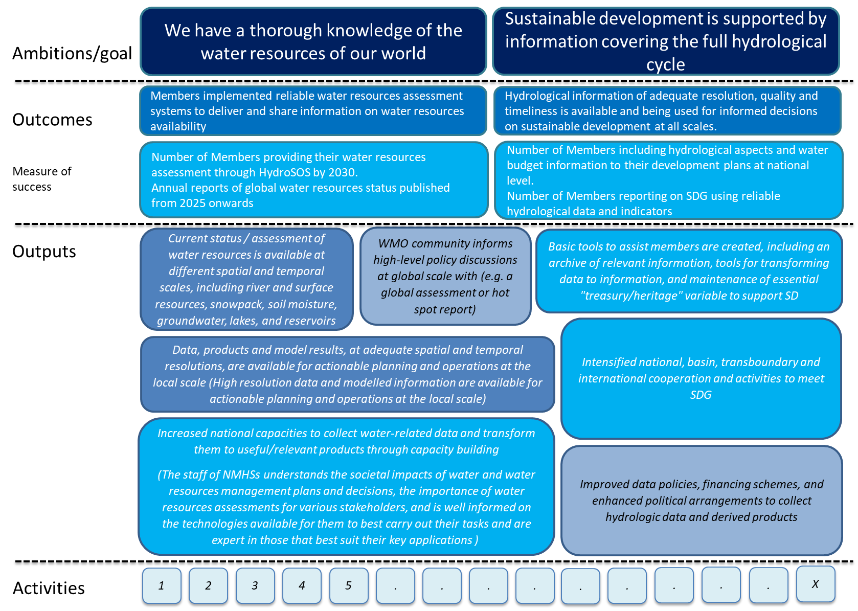
A schematic illustration of resulting proposal is provided in the following figure.
The Table below provides a list of proposed activities grouped by outputs. More details can be found in the following table/document where for some of the activities additional features are proposed (such as responsibility, time, linkages, etc.). The Table is intended to become an integral part of the Action Plan as its annex.
ID |
Activity |
description |
G.1 |
Current status / assessment of water resources is available at different spatial and temporal scales, including river and surface resources, snowpack, soil moisture, groundwater, lakes, and reservoirs |
|
G.1.1 |
Implementation of HydroSOS at global scale , |
HydroSOS is implemented according to its implementation plan – water resources assessment activities at national scale provide inputs to the HydroSOS. |
G.2 |
WMO community informs high-level policy discussions at global scale with (e.g. a global assessment or hot spot report) |
|
G.2.1 |
Developing format and specification for general advisory (specification of the aim, users, content, template, frequency of production, responsibilities) developed |
Concept note on general advisory will be developed as an initial step for operalization |
G.2.2 |
Support network/structure for production of advisory is established (preferably building on regional and global centers of GDPFS) based on 2.1 |
Based on a concept note, a framework and process for production of advisory |
G.2.3 |
Launch of the product and support of its use and sharing |
|
G.3 |
Data, products and model results, at adequate spatial and temporal resolutions, are available for actionable planning and operations at the local scale (High resolution data and modelled information are available for actionable planning and operations at the local scale) |
|
G.3.1 |
Global products for local use – RHSC of GDPS provides to Members WRA products, including training of use, tools for interpretation. |
Develop a system of GDPFS centers that produce data and information specialized to support water resources assessment of Members, based on their requirements. Members are provided with training materials and tools if needed to interpret GDPFS products for national and local applications for WRM. |
G.4 |
Increased national capacities to collect water-related data and transform them to useful/relevant products through capacity building |
|
G.4.1 |
Development and implementation of WRA community of practice (which provides up-to-date information, promotion and enables knowledge transfer in the field of water resources assessment) |
Community of practice for water resources assessment supports NMHSs including support to apply available tools and products (such as DWAT), Community of practice is vital sharing of knowledge and tools across Members. |
G.4.2 |
In frame of G.4.1 a decision tree/check list (comparison engine) is developed to enable selection of proper methodologies and tools for WRA by Members |
|
G.4.3 |
Training curriculum for WRA developed as a part of capacity development strategy of the WMO |
Needs (topical, and on form) of Members are properly identified to propose curricula of courses and training materials in support of capacity building in the domain of WRA |
G.4.4 |
E-learning training course(s) for water resources assessment, |
Based on curricula, courses and training materials are developed |
G.4.5 |
Twinning projects targeted at WRA skills |
Twinning projects between Members target WRA and WRM |
G.4.6 |
Compendium of societal, economic and ecologic relations/dependency on water/hydrological cycle will be developed based on review of existing studies, synergising and collating information. |
|
G.4.7 |
WRA ‘manual’ published |
Finalization of WRA manual and its publication |
|
||
H.1 |
Improved data policies, financing schemes, and enhanced political arrangements to collect hydrologic data and derived products |
|
H.1.1 |
Implementation of resolution 42 at members level (assessment of compliance to provision of essential and desirable data) to enhance the quality of local/national/regional/global observation networks and delivery systems |
See crosscutting activities |
H.1.2 |
Recognition mechanism of centennial station in hydrology |
|
|
for additional see action area on NHSs for cross-cutting data activities |
|
H.2 |
Intensified national, basin, transboundary and international cooperation and activities to meet SDG |
|
H.2.1 |
Supporting building of national, basin and transboundary partnerships for WATER SDGs |
Compilation of success stories and good examples (EU, basin organizations, etc.), basic advice on modes of operation for partnerships of various organizations |
H.2.2 |
Partnership with FAO (AquaStat) and UNESCO established to develop a plan for data/information/products definition to be produced from Members to be collected in global databases supporting the SDG |
|
H.2.3 |
Define set of parameters to monitor and support sustainable development on a long-term scale in cooperation with relevant organisations |
|
H.3 |
Basic tools to assist members are created, including an archive of relevant information, tools for transforming data to information, and maintenance of essential "treasury/heritage" variable to support SD |
|
H.3.1 |
Concept note for WMO hydrology cloud developed (for storage of essential data of Members (based on review of Data centers role)) |
Feasibility study of Hydrology cloud to support SDG and Members – will, need, requirements from Members, viable technical and organisational solutions to be describe |
H.3.2 |
Eventual implementation if agreed by Cg |
|
H.3.3 |
Sharing of data from recognized centennial/reference (GBON-hydrology and Data centers) stations in hydrology |
Need to be updated based on concept of data resolution implementation for hydrology – see also crosscutting activities |
H.3.4 |
SW (cloud solution?) for computation of parameter defined under7.3 |
Supporting Members with automatic computation of selected parameters based on data they measured |
H.3.5 |
Presentation of datasets for evaluation – web presentation of datasets for SDG |
|
Please comment on the list of activities by answering to the following questions using the “Leave a reply” form at the bottom of this page:
- Are any substantial activities missing from your point of view (please keep in mind that, given their nature, they may be also listed under cross-cutting issues)?
- Are all listed activities feasible and meaningful?
- Do you want to propose some changes to definition, description or other features of individual activities? Please refer to ID of the activity.
- Any other comments are welcome as well.
In addition please indicate, using the survey form here below, your preferences concerning the priorities by assigning ‘High priority’ to those activities you consider critical for the Action Plan for Hydrology and which you’d like to promote. At the same time, please assign ‘no priority’ to activities that should be downgraded or dropped from the Action Plan:
This post is open for comments until 25 May 2021 – Extended to 31 May 2021.
Thank you for your inputs!
Yashar Falamarzi26 May 2021 at 7h14
The view of WMO in supporting national and regional hydrological activities is highly appreciated.
nekooamal24 May 2021 at 10h47
Nekooamal from Meteorological Organization of Iran:
Explanation of the paragraph H.1.1:
Many essential water management data, such as water quality data, are not generated by the Meteorological Organization. Also, no index has been specified for the quality of the generated data.
Explanation of the paragraph H.3.3
In many countries, all data are not transferable. It is recommended that general data and specialized data be separated and then the sharing method be specified. For example, general data should be shared for all members and specialized data should be shared only in projects that benefit the parties.
Lea Kauppi21 May 2021 at 18h55
H.2. Enhanced collaboration between UNECE Water Convention and WMO needed to support sustanable management and use of trnasboundary water resources and prevent water conflicts